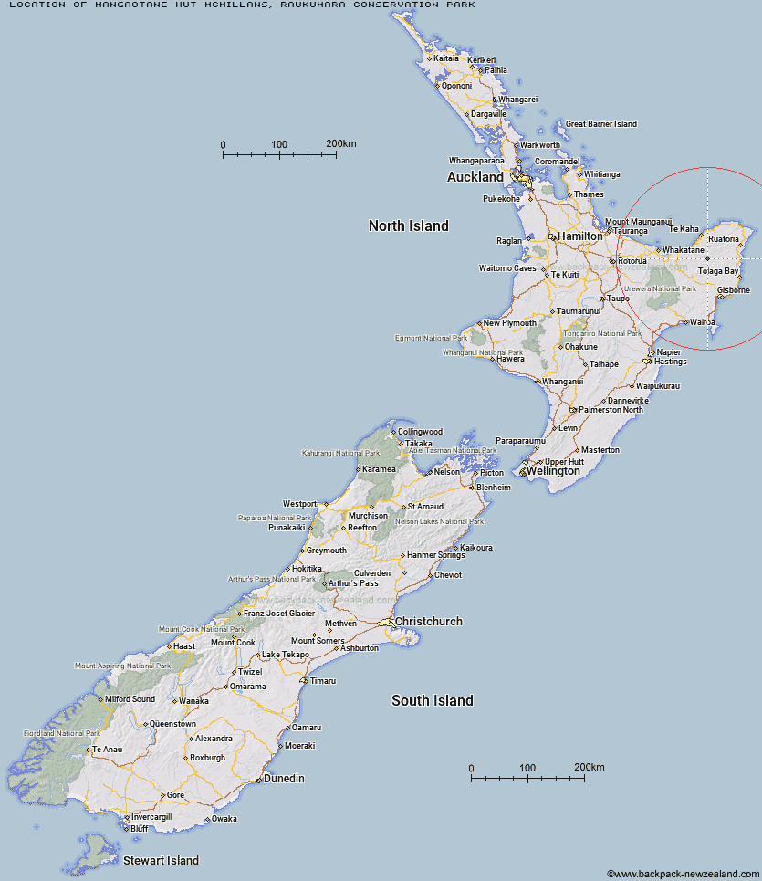
Topo Map showing location of Mangaotane Hut (McMillans)
This information is sourced from DoC, LINZ and Openstreetmap. Some of the hut photos are mine and the rest are from DoC. I will be adding an upload feature soon so people can photos of .Mangaotane Hut (McMillans).
Basic info: basic six-bunk hut in the East Cape area.
Latitude: -38.0991326464
Longitude: 177.774510238
Location: Raukumara Conservation Park
Area: East Coast
Type of Hut: Basic/bivvies
Map: BE42 Topo Map | Road Map
Does this hut still exist? Have any more information? Contact
Basic info: basic six-bunk hut in the East Cape area.
Latitude: -38.0991326464
Longitude: 177.774510238
Location: Raukumara Conservation Park
Area: East Coast
Type of Hut: Basic/bivvies
Map: BE42 Topo Map | Road Map
Does this hut still exist? Have any more information? Contact
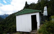
Image: DoC
Scroll down to see a topographical map and road map showing the location of Mangaotane Hut (McMillans)
[ A ] [ B ] [ C ] [ D ] [ E ] [ F ] [ G ] [ H ] [ I ] [ J ] [ K ] [ L ] [ M ] [ N ] [ O ] [ P ] [ Q ] [ R ] [ S ] [ T ] [ U ] [ V ] [ W ] [ Y ] [ Z ]
Closest 20 Huts to Mangaotane Hut (McMillans)
These are as the crow fliesMangakirikiri Hut 12.75km Pakihi Hut 27.98km Pakihi Heads Hut 28.45km Oronui Hut 30.84km Wahaatua Hut 31.28km Hikurangi Hut 32.88km Te Waiti Hut 33.38km Manganuku Hut 35.31km Hastings Hut 35.93km Green Hut 36.02km Lagoon Hut 36.66km Tokenui Hut 37.03km Savlon Hut 37.57km Brills Bivouac 40.04km Kotepato Hut 46.97km Nikau Flat Hut 50.99km Koranga Forks Hut 53.92km Tawa Hut 58.15km Koaunui Hut 58.59km Kahunui Hut 60.64km Makakoere Hut 62.31km Tataweka Hut 62.8km Otapukawa Hut 63.62km Otane Hut 65.09km Onepu Hut 66.78km Wharekahika Hut 66.79km Te Pourewa Hut 68.26km Te Rangaakapua Hut 68.41km Te Pua Hut 69.23km Ohora Hut 70.3km Te Panaa Hut 71.23km Mangatoatoa Hut 71.26km Ohane Hut 72.81km Apiti Hut 73.58km Twain (Waipotiki) Hut 73.97km Makomako Hut 74.41km Waikare Junction Hut 74.8km Saddle (Mangaawai) Hut 75.51km Taurawharona Hut 75.52km Otanetea Hut 76.51km