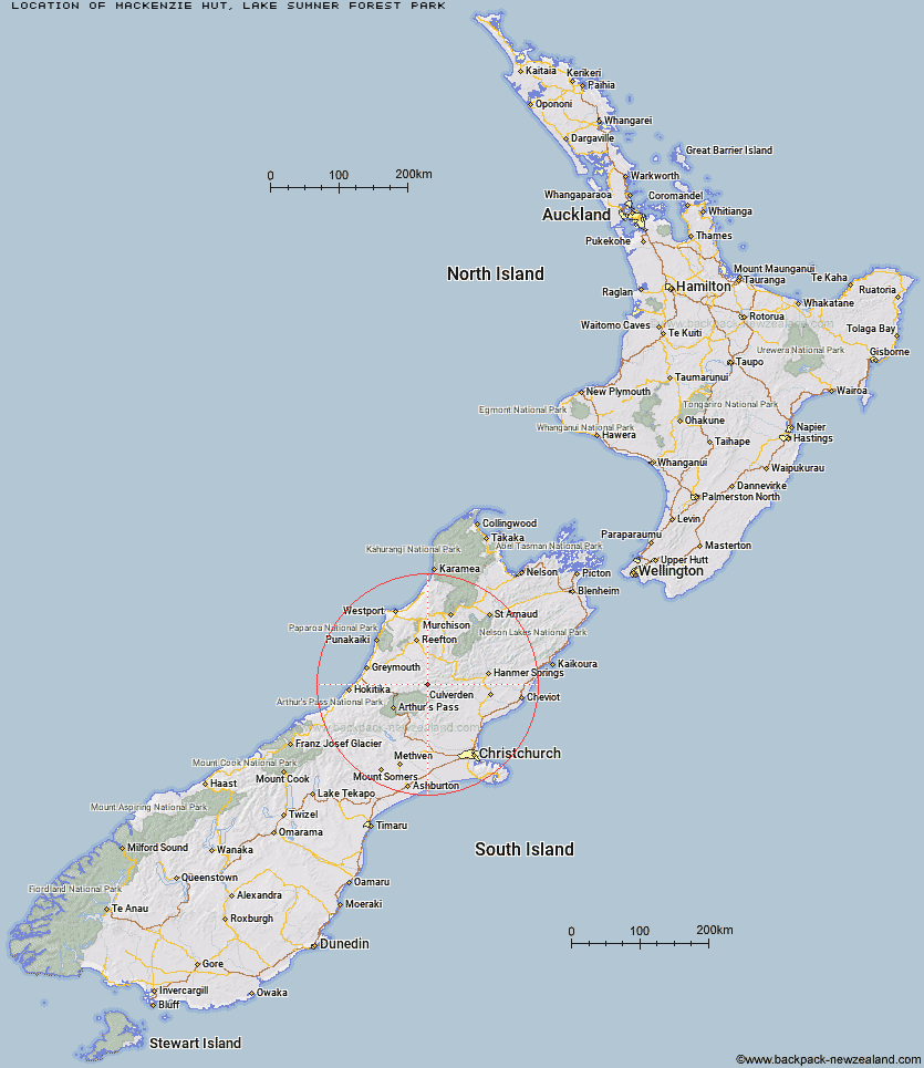
Topo Map showing location of Mackenzie Hut
This information is sourced from DoC, LINZ and Openstreetmap. Some of the hut photos are mine and the rest are from DoC. I will be adding an upload feature soon so people can photos of .Mackenzie Hut.
Basic info: basic six-bunk hut in the North Canterbury and Arthur's Pass area.
Latitude: -42.6483133402
Longitude: 172.018476589
Location: Lake Sumner Forest Park
Area: Canterbury
Type of Hut: Basic/bivvies
Tracks: Hurunui swingbridge tracks & routes
Map: BU22 Topo Map | Road Map
Does this hut still exist? Have any more information? Contact
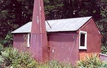
Image: DoC
Scroll down to see a topographical map and road map showing the location of Mackenzie Hut
[ A ] [ B ] [ C ] [ D ] [ E ] [ F ] [ G ] [ H ] [ I ] [ J ] [ K ] [ L ] [ M ] [ N ] [ O ] [ P ] [ Q ] [ R ] [ S ] [ T ] [ U ] [ V ] [ W ] [ Y ] [ Z ]
Closest 20 Huts to Mackenzie Hut
These are as the crow fliesMackenzie Bivouac 3.86km Tutaekuri Hut 5.38km Hurunui No 3 Hut 6.34km Camerons Hut 8.81km Hurunui Hut 8.84km Mid Trent Hut 11.14km Three Mile Stream Hut 11.25km South Branch Research Hut 11.94km Lake Sumner Hut 12.41km Slaty Creek Hut 12.69km Upper South Branch Hurunui Hut 13.11km Harper Pass Bivouac 13.11km Waikiti Hut 13.98km Stony Stream Hut 14.22km Top Hope Hut 14.4km Lake Mason Hut 15.69km Top Trent / Lagoon Hut 16.21km Mid Robinson Hut 17.41km North Esk Hut 17.42km Locke Stream Hut 18.45km Saint Jacob's Hut 18.46km Museum Hut 19.54km Elizabeth Hut 19.72km Candlesticks Bivouac 20.1km Lake Man Bivouac 20.19km Bush Camp Hut 21.22km Evangeline Bivouac 21.62km Doubtless Hut 22.05km Top Robinson Hut 23.05km Hope Halfway Hut 23.15km Minchin Bivouac 23.55km Gabriel Hut 23.62km Cone Creek Hut 23.63km Townsend Hut 24.16km Deep Creek Hut 25.04km Ranger Bivouac 25.12km Ant Stream Bivouac 25.17km Doubtful Hut 25.29km Lake Morgan Hut 25.34km Kiwi Hut 25.52km