Topo Map showing location of Lewis Hut
This information is sourced from DoC, LINZ and Openstreetmap. Some of the hut photos are mine and the rest are from DoC. I will be adding an upload feature soon so people can photos of .Lewis Hut.
Basic info: 20-bunk hut located on the Heaphy Track in the Buller area.
Latitude: -40.9400199421
Longitude: 172.147937515
Location: Kahurangi National Park
Area: Nelson/Tasman
Type of Hut: Great Walk
Tracks: Heaphy Track
Map: map: BP22 Topo Map | Road Map
Does this hut still exist? Have any more information? Contact
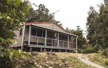
Image: DoC
Scroll down to see a topographical map and road map showing the location of Lewis Hut

[ A ] [ B ] [ C ] [ D ] [ E ] [ F ] [ G ] [ H ] [ I ] [ J ] [ K ] [ L ] [ M ] [ N ] [ O ] [ P ] [ Q ] [ R ] [ S ] [ T ] [ U ] [ V ] [ W ] [ Y ] [ Z ]
Closest 20 Huts to Lewis Hut
These are as the crow fliesHeaphy Hut 6.06km James Mackay Hut 8.34km Katipo Creek Shelter 12.09km Ministry of Works Historic Hut 13.35km Saxon Hut 14.73km Gouland Downs Hut 18.11km Kohaihai Shelter 19.17km Perry Saddle Hut 21.85km Sunshine Flat Shelter 26.22km Brown Hut 27.06km Adams Flat Hut 29.14km Adelaide Tarn Hut 33.22km Fenella Hut 33.93km Cobb Hut 34.17km Lonely Lake Hut 34.75km Greys Hut 34.94km Tent Camp 35.49km Boulder Lake Hut 36.48km Roaring Lion Hut 37.36km Soper Shelter 38.4km Anatoki Forks Hut 38.67km Chaffey Hut 39.43km Trilobite Hut 44.09km Karamea Bend Hut 44.58km Myttons Hut 45.3km Kākāpō Hut 45.54km Sylvester Hut 45.55km Waingaro Forks Hut 45.7km Belltown Manunui Hut 46.17km Balloon Hut 47.24km Crow Hut 47.61km Venus Hut 48.5km Splugeons Rock Shelter 48.6km Wangapeka Bivouac 50.08km Asbestos Cottage 50.27km Dry Rock Shelter 50.43km Growler Rock Shelter 50.88km Riordans Hut 51.28km Thor Hut 51.94km Tin Hut Shelter 52.03km