Topo Map showing location of Kiwi Burn Hut
This information is sourced from DoC, LINZ and Openstreetmap. Some of the hut photos are mine and the rest are from DoC. I will be adding an upload feature soon so people can photos of .Kiwi Burn Hut.
Basic info: standard 12-bunk hut in the Southland area.
Latitude: -45.3550861018
Longitude: 168.090878177
Location: Snowdon Forest Conservation Area
Area: Southland
Type of Hut: Standard
Tracks: Snowdon Forest tramping tracks
Map: CD09 Topo Map | Road Map
Does this hut still exist? Have any more information? Contact
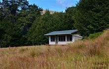
Image: DoC
Scroll down to see a topographical map and road map showing the location of Kiwi Burn Hut

[ A ] [ B ] [ C ] [ D ] [ E ] [ F ] [ G ] [ H ] [ I ] [ J ] [ K ] [ L ] [ M ] [ N ] [ O ] [ P ] [ Q ] [ R ] [ S ] [ T ] [ U ] [ V ] [ W ] [ Y ] [ Z ]
Closest 20 Huts to Kiwi Burn Hut
These are as the crow fliesLincoln Hut 9.4km Upper Oreti Hut 10.18km Army Hut 11.81km Ashton Hut 14.25km Oreti Hut 14.36km Upper Windley Hut 15.24km West Burn Hut 17.28km Lower Windley Hut 18.75km Careys Hut 19.42km Islands Hut 20.03km Upper Cromel Hut 21.04km Irthing Hut 24.12km Dog Box Bivouac 24.17km Cromel Branch Hut 24.79km Boundary Hut 24.93km Forks Hut 26.97km Shepherd Creek Hut 27.19km Lower Princhester Hut 28.66km Cromel Base Hut 28.91km Mt Bee Bunkrooms 29km Cowshed Hut 29.82km Mansion Hut 30.59km Upper Princhester Hut 32.76km Brod Bay Shelter and Campsite 32.98km Billy Hut 33.42km Becketts Hut 34.07km Saint Marys Hut 34.17km Taipo Hut 35.41km Luxmore Hut 37km Aparima Forks Hut 37.33km Cheviot Downs Hut 38.92km Aparima Huts 39.8km Moturau Hut 40.04km Shallow Bay Hut 40.38km Ross Hut 40.43km Whare Creek Hut 40.45km Forest Burn Shelter 40.72km Siberia Hut 41.85km Spence Hut 42.32km Mitchells Hut 42.51km