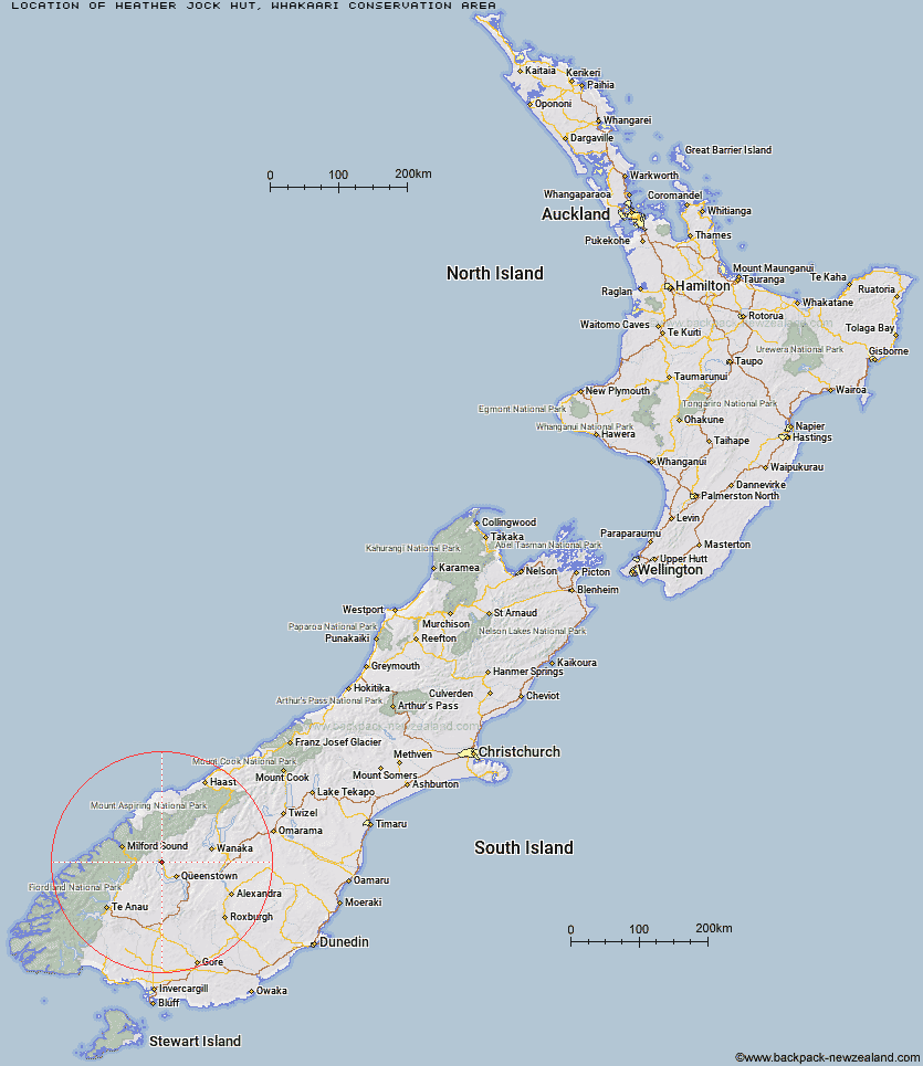
Topo Map showing location of Heather Jock Hut
This information is sourced from DoC, LINZ and Openstreetmap. Some of the hut photos are mine and the rest are from DoC. I will be adding an upload feature soon so people can photos of .Heather Jock Hut.
Basic info: three bunk hut in the Queenstown/Wakatipu area.
Latitude: -44.8542914266
Longitude: 168.455696654
Location: Whakaari Conservation Area
Area: Otago
Type of Hut: Basic/bivvies
Tracks: Mt Judah / Heather Jock Tracks
Map: CB10 Topo Map | Road Map
Does this hut still exist? Have any more information? Contact
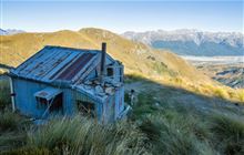
Image: DoC
Scroll down to see a topographical map and road map showing the location of Heather Jock Hut
[ A ] [ B ] [ C ] [ D ] [ E ] [ F ] [ G ] [ H ] [ I ] [ J ] [ K ] [ L ] [ M ] [ N ] [ O ] [ P ] [ Q ] [ R ] [ S ] [ T ] [ U ] [ V ] [ W ] [ Y ] [ Z ]
Closest 20 Huts to Heather Jock Hut
These are as the crow fliesHeather Jock Hut 0km Bonnie Jean Hut 0.74km Jean Hut 0.77km McIntyre's Hut 2.06km Wallers Hut 2.23km McIntosh Hut 2.51km Kelly's Hut 2.9km Stoney Creek Hut 10.41km Mid Caples Hut 14.98km Butchers Hut 15.24km Home Hill Hut 15.51km Archie's Hut - Copper Creek 15.71km Crystal Hut 16.91km Dynamo Hut 17.34km Sainsburys Huts 17.36km Kay Creek Hut 17.61km Slip Flat Hut 18.25km Upper Caples Hut 18.44km Bullendale Hut 18.71km Green Gate Huts 19.23km Ballarat Hut - Flood Burn 19.6km Routeburn Shelter 20.55km Greenstone Hut 20.6km Steele Creek Hut 20.72km Peats Hut 21.06km Sam Summers Hut 22.31km Steele Creek Lodge 22.51km Rats Nest Hut 23.52km Routeburn Flats Hut 23.75km Twenty Five Mile Hut 23.79km Lake Mackenzie Lodge 24.21km Lake Mackenzie Hut 24.25km McKellar Hut 24.56km McKellar Lodge 24.61km Routeburn Falls Hut 24.76km Routeburn Falls Lodge 24.77km Sixteen Mile Huts 25.39km Lake Howden Hut 25.63km Earnslaw Hut 25.86km Esquilant Bivvy Hut 26.84km