Topo Map showing location of Griffin Creek Hut
This information is sourced from DoC, LINZ and Openstreetmap. Some of the hut photos are mine and the rest are from DoC. I will be adding an upload feature soon so people can photos of .Griffin Creek Hut.
Basic info: basic four-bunk hut in the Hokitika area.
Latitude: -42.797824448
Longitude: 171.382778375
Location: Kelly Range - Styx River area
Area: West Coast
Type of Hut: Basic/bivvies
Map: BV19 Topo Map | Road Map
Does this hut still exist? Have any more information? Contact
Basic info: basic four-bunk hut in the Hokitika area.
Latitude: -42.797824448
Longitude: 171.382778375
Location: Kelly Range - Styx River area
Area: West Coast
Type of Hut: Basic/bivvies
Map: BV19 Topo Map | Road Map
Does this hut still exist? Have any more information? Contact
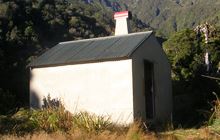
Image: DoC
Scroll down to see a topographical map and road map showing the location of Griffin Creek Hut

[ A ] [ B ] [ C ] [ D ] [ E ] [ F ] [ G ] [ H ] [ I ] [ J ] [ K ] [ L ] [ M ] [ N ] [ O ] [ P ] [ Q ] [ R ] [ S ] [ T ] [ U ] [ V ] [ W ] [ Y ] [ Z ]
Closest 20 Huts to Griffin Creek Hut
These are as the crow fliesRocky Creek Bivouac 2.5km Scottys Bivouac 2.61km Top Olderog Bivouac 4.4km Newton Creek Hut 4.85km Dunns Creek Hut 5.54km Mid Taipo Hut 7.63km Lower Olderog Bivouac 7.69km Dillons Homestead Hut 8.5km Dillon Hut 8.59km Mudflats Hut 8.62km Lower Arahura Hut 9.33km Hunts Creek Hut 10.81km Campbell Bivouac 11.4km Julia Hut 11.61km Old Julia Hut 11.66km Newton Range Bivouac 12.79km Grassy Flat Hut 12.84km Carroll Hut 13.84km Harman Hut 14.43km Browning Range Bivouac 14.84km Mid Styx Hut 15.62km Waimakariri Falls Hut 15.83km Mt Brown Hut 16.87km Top Crawford Hut 17.48km Camp Creek Hut 17.8km Carrington Hut 18.8km Crow Hut 19.54km Park Morpeth Hut 19.63km Jacks Hut 19.73km Boo Boo Hut 20.88km Barker Hut 21.29km Upper Deception Hut 21.38km Crawford Junction Hut 21.75km Jacko Flat Hut 22.58km Pinnacle Bivouac 22.8km Goat Pass Hut 22.86km Pfeifer Bivouac 23.06km Mingha Bivouac 24.47km Anti Crow Hut 24.77km Top Kokatahi Hut 25.96km