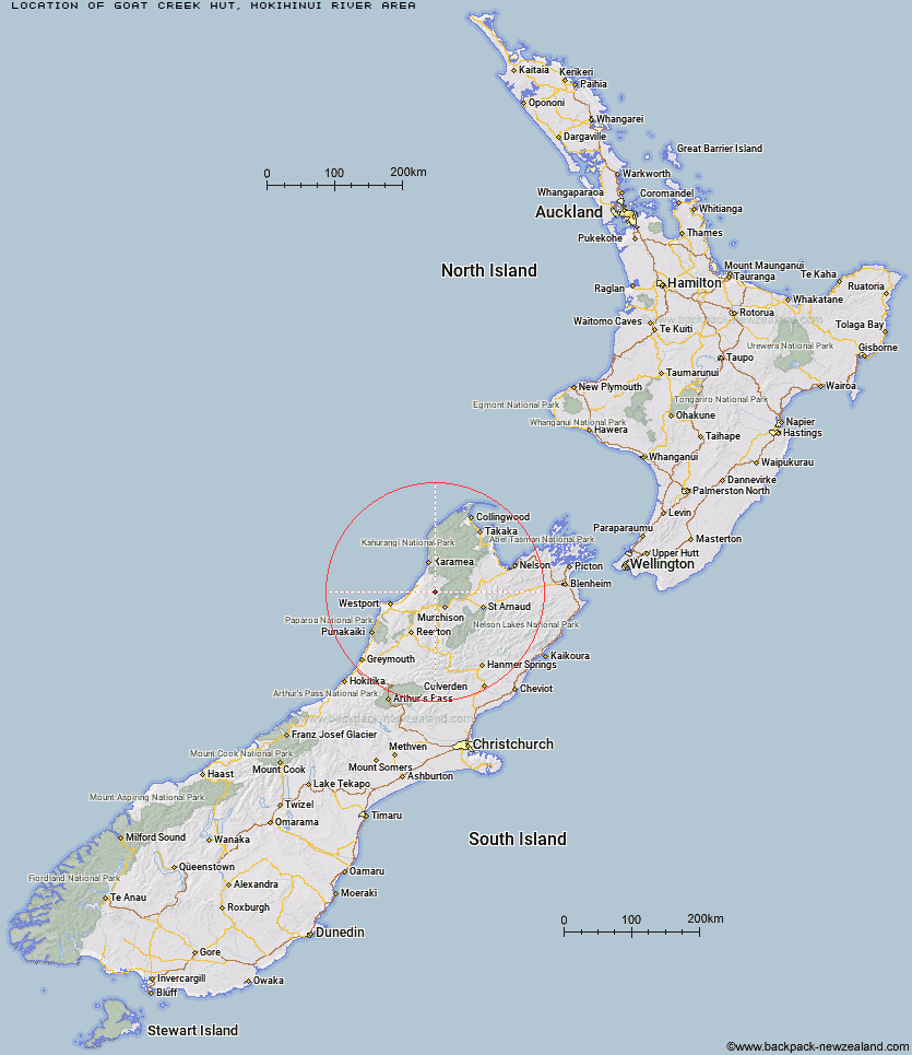
Topo Map showing location of Goat Creek Hut
This information is sourced from DoC, LINZ and Openstreetmap. Some of the hut photos are mine and the rest are from DoC. I will be adding an upload feature soon so people can photos of .Goat Creek Hut.
Basic info: basic four-bunk hut in the Buller area.
Latitude: -41.60585513
Longitude: 172.198666552
Location: Mokihinui River area
Area: West Coast
Type of Hut: Basic/bivvies
Map: BR22 Topo Map | Road Map
Does this hut still exist? Have any more information? Contact
Basic info: basic four-bunk hut in the Buller area.
Latitude: -41.60585513
Longitude: 172.198666552
Location: Mokihinui River area
Area: West Coast
Type of Hut: Basic/bivvies
Map: BR22 Topo Map | Road Map
Does this hut still exist? Have any more information? Contact
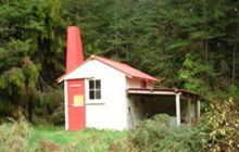
Image: DoC
Scroll down to see a topographical map and road map showing the location of Goat Creek Hut
[ A ] [ B ] [ C ] [ D ] [ E ] [ F ] [ G ] [ H ] [ I ] [ J ] [ K ] [ L ] [ M ] [ N ] [ O ] [ P ] [ Q ] [ R ] [ S ] [ T ] [ U ] [ V ] [ W ] [ Y ] [ Z ]
Closest 20 Huts to Goat Creek Hut
These are as the crow fliesStern Valley Hut 6.43km Mokihinui Forks Hut 6.63km Specimen Point Hut 7.82km Poor Pete's Hut 10.31km Ghost Lake Hut 10.98km Larrikin Creek Hut 11.02km Lake Matiri Hut 12.27km McConchies Hut 13.92km Lyell Saddle Hut 15.5km Johnson Hut 16.69km Hurricane Hut 18.86km Stag Flat Shelter 24.65km Taipo Hut 25.02km Helicopter Flat Hut 25.07km Wangapeka Bivouac 25.97km Branch Creek Hut 27.53km Cecil Kings Hut 28.01km Trevor Carter Hut 28.08km Kings Creek Hut 28.23km Belltown Manunui Hut 28.65km Stone Hut 28.74km Granity Pass Hut 31.53km Kākāpō Hut 31.63km Kiwi Saddle Hut 33.1km Thor Hut 34.46km John Reid Hut 36.97km Venus Hut 37.88km Greys Hut 41.28km Crow Hut 41.39km Adams Flat Hut 45.42km Tiraumea Hut 46.24km Sunshine Flat Shelter 48.2km Karamea Bend Hut 48.95km Roaring Lion Hut 49.41km Flanagans Hut 49.5km D'Urville Hut 49.89km Mole Hut 50.21km Sabine Hut 51.78km Wheel Creek Hut 52km Matakitaki Base Hut 52.76km