Topo Map showing location of Architect Creek Hut
This information is sourced from DoC, LINZ and Openstreetmap. Some of the hut photos are mine and the rest are from DoC. I will be adding an upload feature soon so people can photos of .Architect Creek Hut.
Basic info: standard two-bunk hut in the Glaciers area.
Latitude: -43.6111767405
Longitude: 169.886390265
Location: Westland Tai Poutini National Park
Area: West Coast
Type of Hut: Standard
Tracks: Copland Track to Welcome Flat Hut|Upper Copland Valley Track
Map: BX15 Topo Map | Road Map
Does this hut still exist? Have any more information? Contact
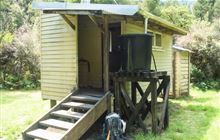
Image: DoC
Scroll down to see a topographical map and road map showing the location of Architect Creek Hut

[ A ] [ B ] [ C ] [ D ] [ E ] [ F ] [ G ] [ H ] [ I ] [ J ] [ K ] [ L ] [ M ] [ N ] [ O ] [ P ] [ Q ] [ R ] [ S ] [ T ] [ U ] [ V ] [ W ] [ Y ] [ Z ]
Closest 20 Huts to Architect Creek Hut
These are as the crow fliesWelcome Flat Hut 5.27km Welcome Flat Campsite 5.3km Cassel Flat Hut 7.12km Horace Walker Hut 9.09km Lame Duck Hut 10.75km Douglas Rock Hut 11.63km Christmas Flat Hut 12.03km Harpers Rock Bivouac 12.92km Sefton Bivvy 17.47km Copland Shelter 17.76km Barron Saddle Hut 18.82km Mueller Hut 18.86km Empress Hut 19.04km Stocking Stream Shelter 19.54km Chancellor Hut 21.12km Caroline Hut 23.06km Reardon Hut 23.18km Richardson Rock Bivouac 24.11km Plateau Hut 24.16km Ball Hut 24.55km Haast Hut 25.18km Pioneer Hut 25.5km Waterfall Hut 26.05km Erceg Hut 26.34km Castle Rocks Hut 28.65km Almer Hut 30.08km Centennial Hut 30.26km Kennedy Hut 30.53km Hende's Hut 30.73km Dodger Hut 31.68km Onslow Hut (Steffan Memorial Hut) 33.86km Littles Hut 33.93km Liebig Hut 34.21km Green Point Hut 34.68km Cullers Hut 34.8km Elcho Hut 35.88km Grough Hut 36.16km Tunnel Creek Hut 36.33km Spencer Rock Bivouac 36.5km Jollie Hut 36.77km