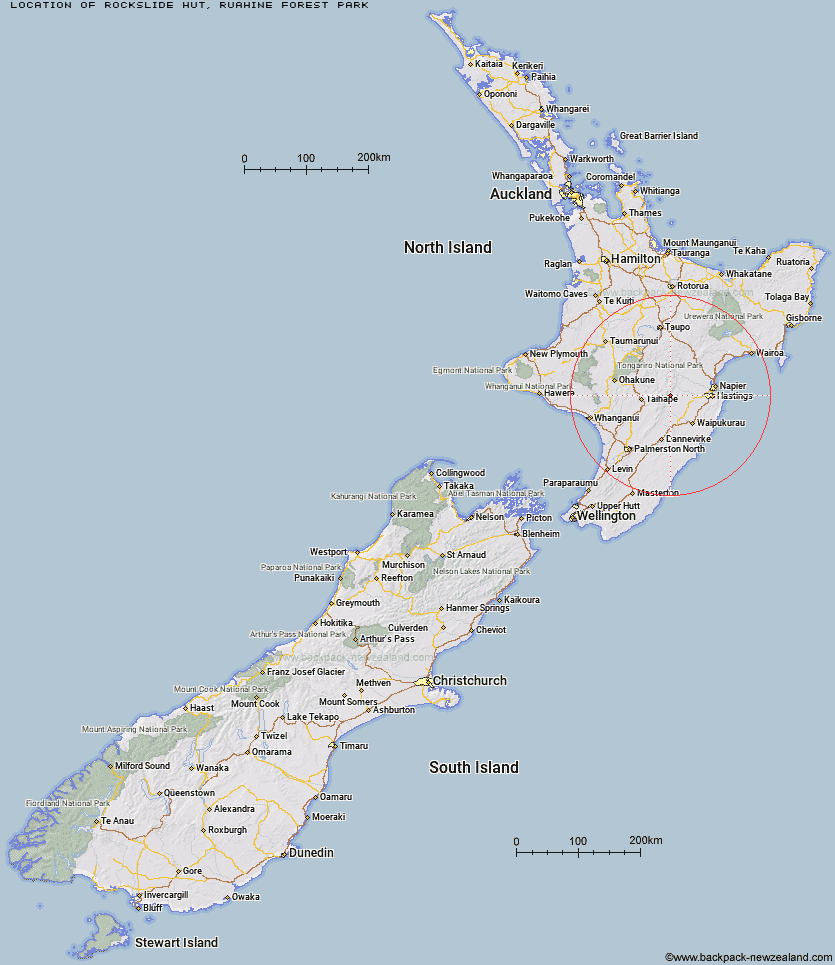
Topo Map showing location of Rockslide Hut
This information is sourced from DoC, LINZ and Openstreetmap. Some of the hut photos are mine and the rest are from DoC. I will be adding an upload feature soon so people can photos of .Rockslide Hut.
Basic info: basic four-bunk hut in the Hawke's Bay region.
Latitude: -39.6151689474
Longitude: 176.225591487
Location: Ruahine Forest Park
Area: Hawke's Bay
Type of Hut: Basic/bivvies
Map: BK37 Topo Map | Road Map
Does this hut still exist? Have any more information? Contact
Basic info: basic four-bunk hut in the Hawke's Bay region.
Latitude: -39.6151689474
Longitude: 176.225591487
Location: Ruahine Forest Park
Area: Hawke's Bay
Type of Hut: Basic/bivvies
Map: BK37 Topo Map | Road Map
Does this hut still exist? Have any more information? Contact
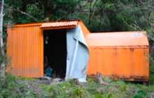
Image: DoC
Scroll down to see a topographical map and road map showing the location of Rockslide Hut
[ A ] [ B ] [ C ] [ D ] [ E ] [ F ] [ G ] [ H ] [ I ] [ J ] [ K ] [ L ] [ M ] [ N ] [ O ] [ P ] [ Q ] [ R ] [ S ] [ T ] [ U ] [ V ] [ W ] [ Y ] [ Z ]
Closest 20 Huts to Rockslide Hut
These are as the crow fliesMistake Bivouac 2.08km Aranga Hut 3.21km Ikawetea Forks Hut 3.68km No Mans Hut 4.71km Ruahine Corner Hut 4.94km Makirikiri Hut 6.28km Upper Makaroro Hut 7.23km Parks Peak Hut 7.26km Dead Dog Hut 7.42km Kylie Bivouac 7.52km Sentry Box Hut 7.62km Masters Shelter 8.35km Taruarau Bivouac 8.98km Dianes Hut 9.49km Colenso Hut 9.6km Herricks Hut 9.8km Ruahine Hut 10.69km Barlow Hut 11.1km Briens Hut 11.38km Tin Hut 11.96km Ellis Hut 11.98km Shutes Hut 12.85km Iron Bark Hut 13.58km Sparrowhawk Bivouac 14.22km Poutaki Hut 14.66km Cedars Hut (Blowfly) 14.68km Maropea Forks Hut 14.76km Otukota Hut 15.47km Gold Creek Hut 16.49km Norris Hut 17.12km Comet Hut 17.22km Wakelings Hut 17.54km Top Maropea Hut 18.63km Sunrise Hut 19.78km Triplex Hut 19.95km Crow Hut 20.72km Waipawa Forks Hut 20.86km McKinnon Hut 21.63km Kawhatau Base 22.47km Waikamaka Hut 23.21km