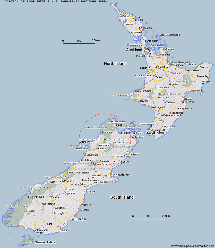
Topo Map showing location of Poor Pete's Hut
This information is sourced from DoC, LINZ and Openstreetmap. Some of the hut photos are mine and the rest are from DoC. I will be adding an upload feature soon so people can photos of .Poor Pete's Hut.
Basic info: basic 2-bunk hut in the Kahurangi National Park.
Latitude: -41.6140554273
Longitude: 172.322186552
Location: Kahurangi National Park
Area: Nelson/Tasman
Type of Hut: Basic/bivvies
Tracks: Matiri Valley and 1000 Acre Plateau tramping tracks
Map: BR23 Topo Map | Road Map
Does this hut still exist? Have any more information? Contact
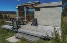
Image: DoC
Scroll down to see a topographical map and road map showing the location of Poor Pete's Hut
[ A ] [ B ] [ C ] [ D ] [ E ] [ F ] [ G ] [ H ] [ I ] [ J ] [ K ] [ L ] [ M ] [ N ] [ O ] [ P ] [ Q ] [ R ] [ S ] [ T ] [ U ] [ V ] [ W ] [ Y ] [ Z ]
Closest 20 Huts to Poor Pete's Hut
These are as the crow fliesMcConchies Hut 4.58km Lake Matiri Hut 4.71km Larrikin Creek Hut 6.04km Goat Creek Hut 10.31km Stern Valley Hut 11.64km Hurricane Hut 12.95km Mokihinui Forks Hut 14.01km Specimen Point Hut 16.1km Ghost Lake Hut 16.59km Johnson Hut 16.75km Branch Creek Hut 18.63km Cecil Kings Hut 20.94km Kings Creek Hut 21.17km Lyell Saddle Hut 22.18km Helicopter Flat Hut 22.25km Granity Pass Hut 22.31km Stone Hut 23.62km Taipo Hut 24.04km Stag Flat Shelter 24.3km Trevor Carter Hut 24.68km Wangapeka Bivouac 26.32km Kiwi Saddle Hut 27.13km John Reid Hut 30.23km Belltown Manunui Hut 30.23km Thor Hut 30.59km Kākāpō Hut 31.35km Venus Hut 34.46km Crow Hut 37.68km Tiraumea Hut 39.13km Greys Hut 41.87km D'Urville Hut 42.11km Sabine Hut 43.66km Mole Hut 43.82km Flanagans Hut 44.17km Speargrass Hut 44.44km Karamea Bend Hut 45.19km Mount Misery Hut 45.84km Angelus Hut 46.72km Roaring Lion Hut 47.2km Bushedge Shelter 47.21km