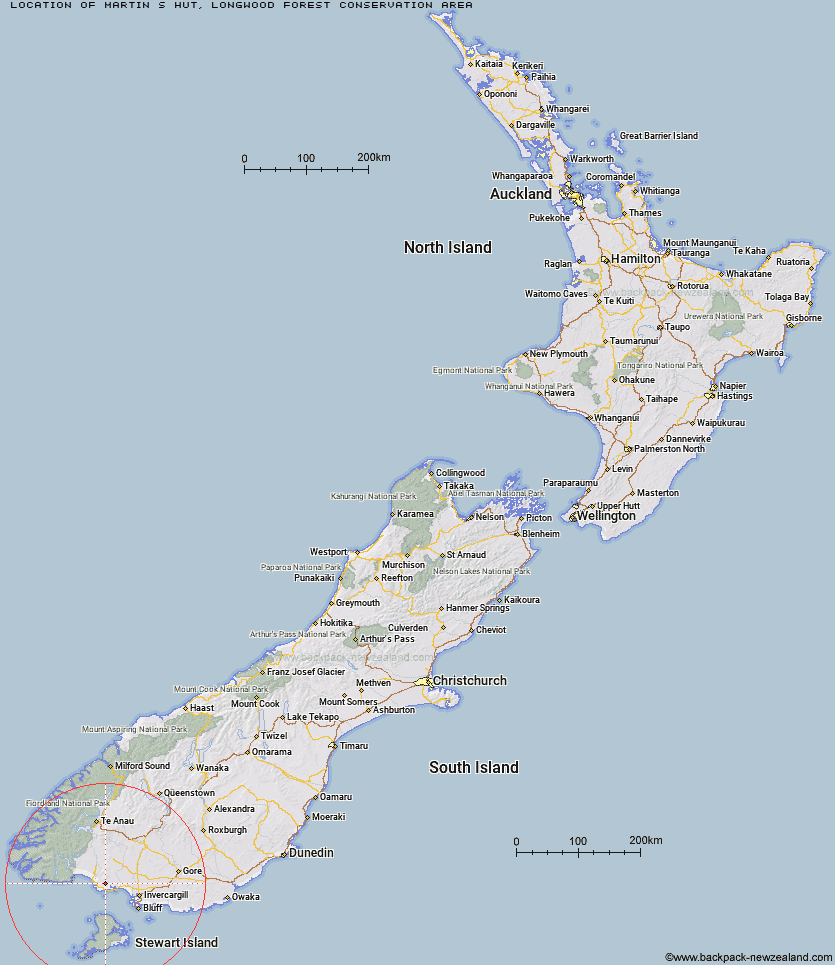
Topo Map showing location of Martin's Hut
This information is sourced from DoC, LINZ and Openstreetmap. Some of the hut photos are mine and the rest are from DoC. I will be adding an upload feature soon so people can photos of .Martin's Hut.
Basic info: basic four-bunk hut in the Southland area. It is a gold-mining era hut built in 1905.
Latitude: -46.2629139526
Longitude: 167.860221598
Location: Longwood Forest Conservation Area
Area: Southland
Type of Hut: Basic/bivvies
Map: CG08 Topo Map | Road Map
Does this hut still exist? Have any more information? Contact
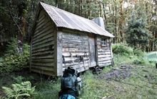
Image: DoC
Scroll down to see a topographical map and road map showing the location of Martin's Hut
[ A ] [ B ] [ C ] [ D ] [ E ] [ F ] [ G ] [ H ] [ I ] [ J ] [ K ] [ L ] [ M ] [ N ] [ O ] [ P ] [ Q ] [ R ] [ S ] [ T ] [ U ] [ V ] [ W ] [ Y ] [ Z ]
Closest 20 Huts to Martin's Hut
These are as the crow fliesTurnbull's (Big Dam) Hut 3.25km Port Craig Lodge 38.61km Port Craig School Hut 38.62km Percy Burn Hut 42.75km Okaka Lodge 43.86km Barcoo Hut 44.97km Rock Hut 47.38km Yankee River Hut 48.07km Long Harry Hut 48.14km Teal Bay Hut 48.71km Smoky Hunters Hut 49.14km Wairaurahiri Hut 49.44km East Ruggedy Hut 51.96km Lower Wairaki Hut 54.11km Christmas Village Hut 54.25km Christmas Village Hunters Hut 55.02km Rodger Inlet Huts 55.39km Telford Hut 56.79km Lake Poteriteri Hut 56.99km Caroline Hut 57.07km Eel Creek Hut 57.2km Murray River Hunters Hut 58.65km Upper Wairaki Hut 58.75km Redcliff Hut 60.33km Waitutu Hut 61.35km Slaughterburn Hut 61.58km Monowai Hut 61.85km Spence Hut 62km Big Hellfire Hut 62.03km Bungaree Hut 62.16km Aparima Huts 62.72km Green Lake Hut 63.87km Aparima Forks Hut 66km Port William Hut 66.02km Whare Creek Hut 66.2km Clark Hut - A Frame 66.37km Freshwater Hut 67.47km Historic Clark Hut 67.66km Becketts Hut 68.47km Borland Bivouac 69.34km