Topo Map showing location of Kauritatahi Hut
This information is sourced from DoC, LINZ and Openstreetmap. Some of the hut photos are mine and the rest are from DoC. I will be adding an upload feature soon so people can photos of .Kauritatahi Hut.
Basic info: basic three-bunk hut in the Tauranga area.
Latitude: -37.6650393271
Longitude: 175.861218468
Location: Kaimai Mamaku Forest Park
Area: Bay of Plenty
Type of Hut: Basic/bivvies
Tracks: North-South Track
Map: BD36 Topo Map | Road Map
Does this hut still exist? Have any more information? Contact
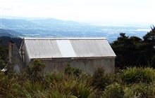
Image: DoC
Scroll down to see a topographical map and road map showing the location of Kauritatahi Hut

[ A ] [ B ] [ C ] [ D ] [ E ] [ F ] [ G ] [ H ] [ I ] [ J ] [ K ] [ L ] [ M ] [ N ] [ O ] [ P ] [ Q ] [ R ] [ S ] [ T ] [ U ] [ V ] [ W ] [ Y ] [ Z ]
Closest 20 Huts to Kauritatahi Hut
These are as the crow fliesMotutapere Hut 5.11km Te Rereatukahia Hut 9.19km Ngamuwahine Shelter 13.36km Wairoa Shelter 13.51km Mangamuka Hut 14.01km Waitawheta Hut 16.17km Hurunui Hut 17.95km Mangakino Shelter 19.38km Daly's Clearing Hut 21.86km Pinnacles Hut 70.51km Crosbies Hut 72.55km Pahautea Hut 76.8km Wairua Hut 80.7km Wildlife Hut 86.91km Piggotts Hut 89.17km Hamilton Tomo Group Hut 93.99km Bog Inn Hut 104.1km Waihua Hut 112.88km Mangamako Hut 114.39km Twain (Waipotiki) Hut 115.45km Saddle (Mangaawai) Hut 116.35km Waihaha Hut 116.77km Casino Hut 116.78km Duckville Hut 118.18km Horomanga Base Camp 118.44km Apiti Hut 118.55km Wharekahika Hut 121.68km Hauhungaroa Hut 124.25km Manaohou Right Branch Hut 124.41km Ohora Hut 124.44km Okui Hut 125.53km Leitchs Hut 127.55km Onepu Hut 128.33km Hanamahihi Hut 128.35km Waikare Junction Hut 128.52km Mangapouri Hut 128.83km Ohane Hut 131.19km Ngahiramai Hut 134.21km Takurua Hut 135.2km Tawhiwhi Hut 136.47km