Topo Map showing location of Green Point Hut
This information is sourced from DoC, LINZ and Openstreetmap. Some of the hut photos are mine and the rest are from DoC. I will be adding an upload feature soon so people can photos of .Green Point Hut.
Basic info: Green Point Hut is in the Jollie River catchment within Gamack Conservation Area.
Latitude: -43.7901838513
Longitude: 170.239672726
Location: Gamack Conservation Area
Area: Canterbury
Type of Hut: Basic/bivvies
Map: BY16 Topo Map | Road Map
Does this hut still exist? Have any more information? Contact
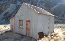
Image: DoC
Scroll down to see a topographical map and road map showing the location of Green Point Hut

[ A ] [ B ] [ C ] [ D ] [ E ] [ F ] [ G ] [ H ] [ I ] [ J ] [ K ] [ L ] [ M ] [ N ] [ O ] [ P ] [ Q ] [ R ] [ S ] [ T ] [ U ] [ V ] [ W ] [ Y ] [ Z ]
Closest 20 Huts to Green Point Hut
These are as the crow fliesLittles Hut 5.81km Jollie Hut 7.71km Waterfall Hut 11.91km Tin Hut 13.94km Ryders Hut 14.01km Stocking Stream Shelter 15.33km Mueller Hut 15.99km Birdcage Hut 17.03km Maryburn Hut 17.04km Memorial Hut 17.07km Sefton Bivvy 17.4km Caroline Hut 18.04km Middle Gorge Hut 18.08km Ball Hut 18.81km Copland Shelter 18.82km Liebig Hut 18.83km Reardon Hut 19.35km Barron Saddle Hut 19.52km Waterfall Hut 20.67km Onslow Hut (Steffan Memorial Hut) 20.81km Whale Stream Hut 21.17km Telegraph Hut 22.01km Harpers Rock Bivouac 22.94km Haast Hut 23.32km Plateau Hut 23.4km Douglas Rock Hut 23.4km Ribbonwood Hut 23.49km Empress Hut 23.72km Angus Hut 24.17km Kennedy Hut 24.29km Richardson Rock Bivouac 25.98km Erceg Hut 26.74km Christmas Flat Hut 27.78km Horace Walker Hut 27.89km Rankin Hut 28.22km Grough Hut 28.38km Pioneer Hut 29.13km Welcome Flat Campsite 29.5km Welcome Flat Hut 29.53km Station Hut 30km