Topo Map showing location of Central Waiau Hut
This information is sourced from DoC, LINZ and Openstreetmap. Some of the hut photos are mine and the rest are from DoC. I will be adding an upload feature soon so people can photos of .Central Waiau Hut.
Basic info: standard eight-bunk hut in the Te Urewera area.
Latitude: -38.7681023906
Longitude: 176.846944711
Location: Te Urewera
Area: East Coast
Type of Hut: Standard
Map: BG39 Topo Map | Road Map
Does this hut still exist? Have any more information? Contact
Basic info: standard eight-bunk hut in the Te Urewera area.
Latitude: -38.7681023906
Longitude: 176.846944711
Location: Te Urewera
Area: East Coast
Type of Hut: Standard
Map: BG39 Topo Map | Road Map
Does this hut still exist? Have any more information? Contact
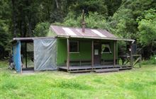
Image: DoC
Scroll down to see a topographical map and road map showing the location of Central Waiau Hut

[ A ] [ B ] [ C ] [ D ] [ E ] [ F ] [ G ] [ H ] [ I ] [ J ] [ K ] [ L ] [ M ] [ N ] [ O ] [ P ] [ Q ] [ R ] [ S ] [ T ] [ U ] [ V ] [ W ] [ Y ] [ Z ]
Closest 20 Huts to Central Waiau Hut
These are as the crow fliesTe Totara Hut 4.71km Te Waiotukapiti Hut 4.76km Rogers Hut (Te Wairoa) 5.28km Skips Hut (Whangatawhia) 6.66km Mangakahika Hut 7.73km Moerangi Hut 10.93km Marauiti Hut 12.91km Central Te Hoe Hut 13.01km Waiopaoa Hut 13.53km Upper Te Hoe Hut 13.58km Mangamate Hut 13.76km Vern's Camp Shelter 15.33km Whakatakaa Hut 15.82km Upper Whirinaki Hut 15.87km Waiharuru Hut 16.33km Central Whirinaki Hut 16.83km Whanganui Hut 17.56km Panekire Hut 18.42km Kanohirua Hut 23.98km Mangapouri Hut 25.8km Upper Matakuhia Hut 25.9km Manuoha Hut 26.83km Okui Hut 27.35km Lower Matakuhia Hut 28.33km Waiawa Hut 28.5km Halfway Hut 29.2km Sandy Bay Hut 30.58km Tawhiwhi Hut 31.02km Ngahiramai Hut 32.7km Takurua Hut 34.87km Taurawharona Hut 35.18km Makomako Hut 35.54km Otanetea Hut 35.7km Mangatoatoa Hut 38.57km Hanamahihi Hut 38.85km Lower Ohane Hut 39.68km Horomanga Base Camp 39.8km Manaohou Right Branch Hut 39.96km Te Panaa Hut 40.73km Te Rangaakapua Hut 41.42km