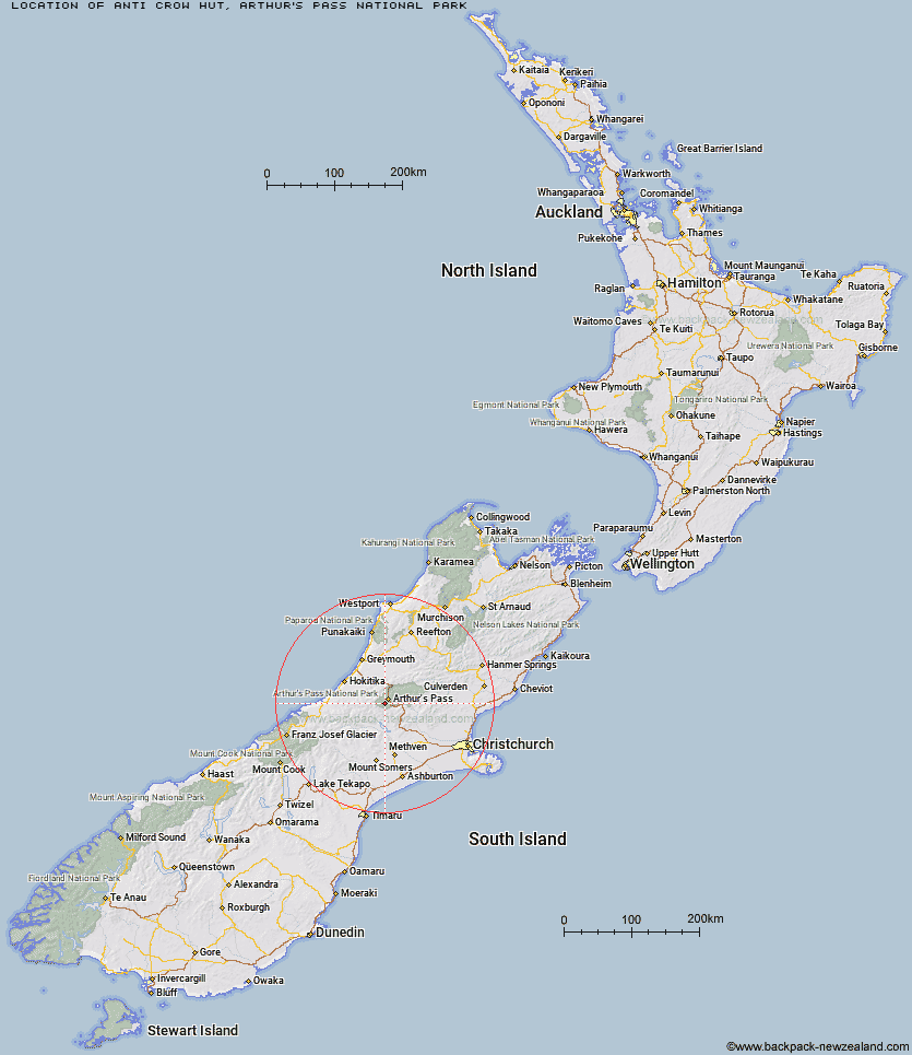
Topo Map showing location of Anti Crow Hut
This information is sourced from DoC, LINZ and Openstreetmap. Some of the hut photos are mine and the rest are from DoC. I will be adding an upload feature soon so people can photos of .Anti Crow Hut.
Basic info: standard six-bunk hut in the North Canterbury and Arthur's Pass area.
Latitude: -42.9996531427
Longitude: 171.511388676
Location: Arthur's Pass National Park
Area: Canterbury
Type of Hut: Standard
Tracks: Carrington Hut Route
Map: BV20 Topo Map | Road Map
Does this hut still exist? Have any more information? Contact
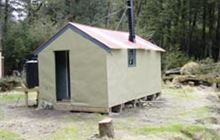
Image: DoC
Scroll down to see a topographical map and road map showing the location of Anti Crow Hut
[ A ] [ B ] [ C ] [ D ] [ E ] [ F ] [ G ] [ H ] [ I ] [ J ] [ K ] [ L ] [ M ] [ N ] [ O ] [ P ] [ Q ] [ R ] [ S ] [ T ] [ U ] [ V ] [ W ] [ Y ] [ Z ]
Closest 20 Huts to Anti Crow Hut
These are as the crow fliesBealey Spur Hut 6.03km Crow Hut 6.27km Klondyke Shelter 6.33km Greyneys Shelter 6.64km Carrington Hut 6.77km Avoca Hut 8.89km Waimakariri Falls Hut 9.32km Barker Hut 9.33km Lagoon Saddle Hut 9.52km Lagoon Saddle A Frame Hut 9.59km Jacks Hut 9.71km Bealey Hut 11.41km Old Basins Hut 11.43km Back Basin Hide 11.6km Basins Hut 11.63km Edwards Hut 12.84km Mingha Bivouac 12.89km Old Julia Hut 13.3km Julia Hut 13.36km West Harper Hut 13.58km Park Morpeth Hut 14.13km Goat Pass Hut 14.29km Weka Burnet Bivouac 15.29km Upper Deception Hut 15.46km Urquhart's Hut 16.26km Sudden Valley Bivouac 16.67km Campbell Bivouac 16.94km Hamilton Hut 17.34km Mid Taipo Hut 17.53km Hunts Creek Hut 17.69km Harman Hut 17.83km Mudflats Hut 18.13km Cass Saddle Hut 18.24km Fanghill Hut 18.27km Hawdon Shelter 19.23km Dunns Creek Hut 19.54km Moa Hut 19.58km Top Crawford Hut 20.23km Hawdon Hut 20.53km Unknown Stream Hut 20.68km