Map showing location of Rainy River


LINZ description: Feature shown on: NZMS260 O27 Edition 2 1994
Latitude: -41.344667
Longitude: 173.506139
Northing: 5422857
Easting: 1642344.6
Land District: Marlborough
Feat Type: Stream
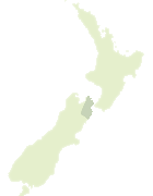

Scroll down to see a more detailed road map and below that a topographical map showing the location of Rainy River. The road map has been supplied by openstreetmap and the topographical map of Rainy River has been supplied by Land Information New Zealand (LINZ).

Yes you can use the top static map for you school/university project or personal website with a link back. Contact me for any commercial use.

Rainy River Map New Zealand


New Zealand places in our database
[ A ] [ B ] [ C ] [ D ] [ E ] [ F ] [ G ] [ H ] [ I ] [ J ] [ K ] [ L ] [ M ] [ N ] [ O ] [ P ] [ Q ] [ R ] [ S ] [ T ] [ U ] [ V ] [ W ] [ X ] [ Y ] [ Z ]


Closest 20 Streams to Rainy River

Rainy River ( 0km )   Te Hoiere / Pelorus River ( 4.21km )   Pelorus River ( 4.21km )   Bryants Stream ( 4.62km )   Franklin Creek ( 5.41km )   Scott Creek ( 5.54km )   Johnson Creek ( 5.72km )   Elvy Stream ( 5.91km )   K?huru Creek ( 6.05km )   Heringa Stream ( 6.61km )   Banks Creek ( 6.81km )   Captain Creek ( 7.11km )   Camp Creek ( 7.63km )   All Nations Creek ( 7.8km )   Kleyne Stream ( 8.18km )   Tinline River ( 8.35km )   Wakamarina River ( 8.38km )   Bullock Hide Creek ( 9.31km )   Fishtail Stream ( 9.44km )   Dead Horse Creek ( 9.73km )   M?hanga Creek ( 10.14km )   Flat Creek ( 10.8km )   Foster Creek ( 10.94km )   Middy Creek ( 10.95km )   Beachamp Creek ( 11.01km )   Little Mountain Camp Creek ( 11.12km )   Devils Creek ( 11.12km )   The Wrey ( 11.16km )   Deep Creek ( 11.18km )   Doom Creek ( 11.22km )   Little Deep Creek ( 11.25km )   Maitai River North Branch ( 11.35km )   Mill Creek ( 11.38km )   Swift Stream ( 12.01km )   Rocks Creek ( 12.19km )   Maitai River South Branch ( 12.23km )   Thompson Stream ( 12.31km )   Quayle Stream ( 12.38km )   Slater Creek ( 12.73km )   Greek Stream ( 12.88km )