Map showing location of Banks Creek


LINZ description: Feature shown on: NZMS260 O28 Edition 1 1985
Latitude: -41.398694
Longitude: 173.544583
Northing: 5416839.5
Easting: 1645523.3
Land District: Marlborough
Feat Type: Stream
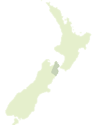

Scroll down to see a more detailed road map and below that a topographical map showing the location of Banks Creek. The road map has been supplied by openstreetmap and the topographical map of Banks Creek has been supplied by Land Information New Zealand (LINZ).

Yes you can use the top static map for you school/university project or personal website with a link back. Contact me for any commercial use.

Banks Creek Map New Zealand


New Zealand places in our database
[ A ] [ B ] [ C ] [ D ] [ E ] [ F ] [ G ] [ H ] [ I ] [ J ] [ K ] [ L ] [ M ] [ N ] [ O ] [ P ] [ Q ] [ R ] [ S ] [ T ] [ U ] [ V ] [ W ] [ X ] [ Y ] [ Z ]


Closest 20 Streams to Banks Creek

Johnson Creek ( 3.36km )   Devils Creek ( 4.45km )   Foster Creek ( 5.43km )   Kleyne Stream ( 6.21km )   Wakamarina River ( 6.47km )   Dead Horse Creek ( 6.7km )   Rainy River ( 6.81km )   All Nations Creek ( 7.16km )   Doom Creek ( 7.38km )   Quartz Creek ( 8.12km )   Criterion Creek ( 8.22km )   Deep Creek ( 8.63km )   Bullock Hide Creek ( 8.94km )   Bryants Stream ( 9.04km )   Little Deep Creek ( 9.34km )   Te Hoiere / Pelorus River ( 9.77km )   Pelorus River ( 9.77km )   Elvy Stream ( 9.92km )   Watts Stream ( 10.13km )   Ellis Creek ( 10.24km )   Fishtail Stream ( 10.4km )   Thompson Stream ( 10.42km )   Thomsons Creek ( 10.69km )   Greek Stream ( 10.83km )   Little Mountain Camp Creek ( 10.83km )   Fabians Creek ( 10.89km )   Cockatoo Creek ( 10.98km )   Nuggety Stream ( 11.15km )   Appletree Creek ( 11.15km )   Bartletts Creek ( 11.19km )   Pine Valley Stream ( 11.24km )   Mortimer Stream ( 11.29km )   Hopeless Creek ( 11.3km )   Scott Creek ( 11.58km )   Captain Creek ( 11.65km )   Atahaua Stream ( 11.72km )   Franklin Creek ( 11.98km )   Oliver Stream ( 12km )   Quayle Stream ( 12.08km )   Sellars Stream ( 12.15km )