Map showing location of Floodgate Creek


LINZ description: Feature shown on: NZMS260 O31
Latitude: -42.342139
Longitude: 173.599889
Northing: 5312061.1
Easting: 1649414.4
Land District: Marlborough
Feat Type: Stream
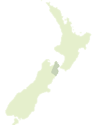

Scroll down to see a more detailed road map and below that a topographical map showing the location of Floodgate Creek. The road map has been supplied by openstreetmap and the topographical map of Floodgate Creek has been supplied by Land Information New Zealand (LINZ).

Yes you can use the top static map for you school/university project or personal website with a link back. Contact me for any commercial use.

Floodgate Creek Map New Zealand


New Zealand places in our database
[ A ] [ B ] [ C ] [ D ] [ E ] [ F ] [ G ] [ H ] [ I ] [ J ] [ K ] [ L ] [ M ] [ N ] [ O ] [ P ] [ Q ] [ R ] [ S ] [ T ] [ U ] [ V ] [ W ] [ X ] [ Y ] [ Z ]


Closest 20 Streams to Floodgate Creek

Goldmine Creek ( 2.33km )   Luke Creek ( 2.87km )   Kowhai River ( 3.01km )   Sandy Creek ( 3.3km )   Middle Creek ( 4.21km )   Rokomaiwhaea Creek ( 4.49km )   Orange Grove Creek ( 4.49km )   Middlehead Stream ( 4.94km )   Waimangarara River ( 4.98km )   Ewelme Stream ( 5.74km )   Snowflake Stream ( 6.63km )   Bellbird Stream ( 6.67km )   Long Creek ( 6.76km )   Harnetts Creek ( 7.18km )   Humbug Stream ( 7.23km )   Cribb Creek ( 7.54km )   Lyell Creek ( 8.19km )   Elms Creek ( 9.06km )   Mill Creek ( 9.39km )   Rakaunui Stream ( 10.58km )   Stace Creek ( 10.71km )   Linton Creek ( 11.18km )   Hapuku River ( 11.68km )   Little Linton Creek ( 11.75km )   Wairere Stream ( 12.18km )   Rosy Morn Stream ( 12.98km )   Kie Kie Stream ( 13.75km )   Clinton River ( 14.04km )   Puhi Puhi River ( 14.14km )   Blue Duck Creek ( 14.29km )   Split Rock Stream ( 14.66km )   Kahutara River ( 14.69km )   Stace Creek ( 14.9km )   Green Burn ( 14.91km )   Cold Stream ( 14.93km )   Jordan Stream ( 16.2km )   Ote Makura Stream ( 16.24km )   Limestone Stream ( 16.27km )   Waikeene or Tukutukuiwi Stream ( 16.41km )   Irongate Stream ( 16.79km )