Map showing location of Airedale Reef


LINZ description: Feature shown on: NZMS260 Q19
Latitude: -38.981389
Longitude: 174.24
Northing: 5684557.5
Easting: 1707403.7
Land District: Taranaki
Feat Type: Reef


Scroll down to see a more detailed road map and below that a topographical map showing the location of Airedale Reef. The road map has been supplied by openstreetmap and the topographical map of Airedale Reef has been supplied by Land Information New Zealand (LINZ).

Yes you can use the top static map for you school/university project or personal website with a link back. Contact me for any commercial use.
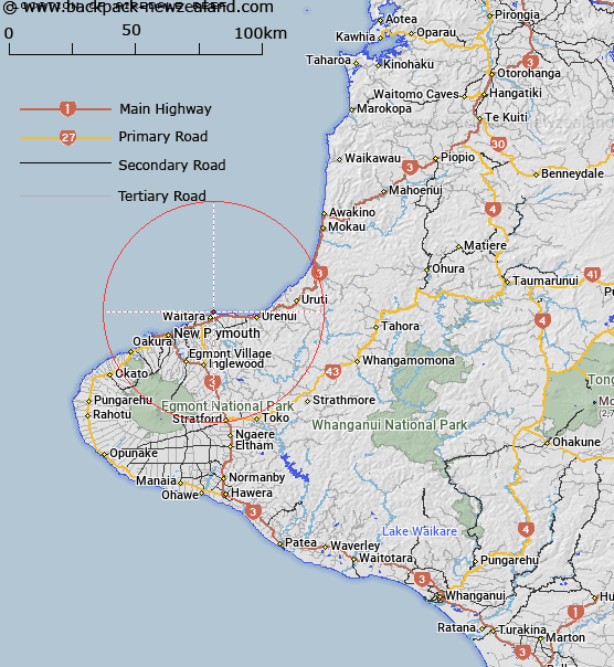
Airedale Reef Map New Zealand


New Zealand places in our database
[ A ] [ B ] [ C ] [ D ] [ E ] [ F ] [ G ] [ H ] [ I ] [ J ] [ K ] [ L ] [ M ] [ N ] [ O ] [ P ] [ Q ] [ R ] [ S ] [ T ] [ U ] [ V ] [ W ] [ X ] [ Y ] [ Z ]


Closest 20 Reefs to Airedale Reef

Kawaroa Reef ( 17.22km )   Corinna Rocks ( 19.81km )   Hapuku Rock ( 22.49km )   Piritoki Reef ( 75.43km )   Waioioi Reef ( 102.9km )   Aotea Reef ( 118.43km )   Jacksons Reef (Patuatini) ( 130.75km )   Jacksons Reef ( 130.75km )   Witts Rock ( 209.5km )   Hinemoa Rocks ( 213.1km )   Pelorus Rock ( 214.27km )   McManaway Rock ( 217.67km )   Passage Rocks ( 218.44km )   Te Kawau a Toru ( 218.65km )   Duffers Reef ( 219.78km )   Hope Rock ( 224.71km )   Catamaran Reef ( 231.66km )   Kapukapuariki Rocks ( 232.19km )   Stella Rock ( 234.52km )   Bark Bay Reef ( 237.37km )   Town Reef ( 238.12km )   P?nia Reef ( 238.18km )   P?nia Rock ( 238.72km )   ?kura Rock ( 239.95km )   Te Tokaroa Reef ( 241.73km )   H?puku Reef ( 241.74km )   Okaparu Reef ( 241.97km )   Titokarua Reef ( 242.17km )   Pudney Rock ( 243.48km )   West Bastion Reef ( 243.92km )   East Bastion Reef ( 243.96km )   Rough Rock ( 245.93km )   Hawes Rock ( 245.97km )   Iliomama Rock ( 248.16km )   Luke Rock ( 249.02km )   Astrolabe Reef ( 249.03km )   Sunday Rock ( 250.36km )   Scully Reef ( 252.64km )   Black Reef ( 254.99km )   Mercia Rock ( 257.29km )