Map showing location of Te Tahanga-o-te-konawhiti


LINZ description: Unidentifiable locality. Nuhaka North Survey District.
Latitude: -38.844781
Longitude: 177.800928
Northing: 5689482.9
Easting: 2016732.3
Land District: Gisborne
Feat Type: Locality
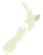

Scroll down to see a more detailed road map and below that a topographical map showing the location of Te Tahanga-o-te-konawhiti. The road map has been supplied by openstreetmap and the topographical map of Te Tahanga-o-te-konawhiti has been supplied by Land Information New Zealand (LINZ).

Yes you can use the top static map for you school/university project or personal website with a link back. Contact me for any commercial use.

Te Tahanga-o-te-konawhiti Map New Zealand


New Zealand places in our database
[ A ] [ B ] [ C ] [ D ] [ E ] [ F ] [ G ] [ H ] [ I ] [ J ] [ K ] [ L ] [ M ] [ N ] [ O ] [ P ] [ Q ] [ R ] [ S ] [ T ] [ U ] [ V ] [ W ] [ X ] [ Y ] [ Z ]


Closest 20 Localitys to Te Tahanga-o-te-konawhiti

Waingake ( 6.54km )   Wharerata ( 7.75km )   Papakiateaio ( 9.97km )   Papakiateaia ( 9.97km )   Pukearia ( 10.51km )   Pukiaria ( 10.51km )   Rangikaikitia ( 10.52km )   Rangikahikitia ( 10.52km )   Anaotamaraukura ( 10.63km )   Te Ana Taumaraukura ( 10.63km )   Mamaka ( 10.8km )   Mamaku ( 10.8km )   Poakahitia ( 10.87km )   Pouakahutia ( 10.87km )   Taikawakawa ( 10.95km )   Kaikauakaua ( 10.95km )   Konohuri Kahawai ( 11.07km )   Powhirikahawai ( 11.07km )   Otitangi ( 12.13km )   Otirangi ( 12.13km )   Paotara ( 14.39km )   Potara ( 14.39km )   Waiwhero ( 14.77km )   Te Wai Wero ( 14.77km )   Muriwai ( 14.98km )   Morere ( 15.17km )   Te Rerengaotukiriahi ( 16.52km )   Waerengaokuri ( 17.53km )   Tukemokihi ( 18.12km )   Tukemakihi ( 18.12km )   Mahanga Beach ( 20.37km )   Manutuke ( 20.45km )   Tiniroto ( 21.81km )   Nuhaka ( 22.97km )   Tahaenui ( 23.88km )   Hangaroa ( 24.07km )   Te Reinga ( 24.16km )   Matawhero ( 24.42km )   Waikokopu ( 25.49km )   Makaraka ( 25.6km )