Map showing location of Tawapata Bay


LINZ description: Found on the east coast of Mahia Peninsula.
Latitude: -39.20085
Longitude: 177.917337
Northing: 5649400
Easting: 2024700
Land District: Hawke's Bay
Feat Type: Bay
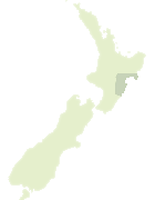

Scroll down to see a more detailed road map and below that a topographical map showing the location of Tawapata Bay. The road map has been supplied by openstreetmap and the topographical map of Tawapata Bay has been supplied by Land Information New Zealand (LINZ).

Yes you can use the top static map for you school/university project or personal website with a link back. Contact me for any commercial use.

Tawapata Bay Map New Zealand


New Zealand places in our database
[ A ] [ B ] [ C ] [ D ] [ E ] [ F ] [ G ] [ H ] [ I ] [ J ] [ K ] [ L ] [ M ] [ N ] [ O ] [ P ] [ Q ] [ R ] [ S ] [ T ] [ U ] [ V ] [ W ] [ X ] [ Y ] [ Z ]


Closest 20 Bays to Tawapata Bay

Ahuriri Bay ( 7.42km )   Moemoto Bay ( 9.1km )   Waitaniwha Bay ( 17.4km )   Happy Jacks Boat Harbour ( 21.25km )   Whareongaonga Bay ( 37.98km )   Poverty Bay ( 54.86km )   Sponge Bay ( 56.36km )   Shark Bay ( 57.04km )   Te Ikaarongamai Bay ( 79.15km )   Onepoto Bay ( 82.25km )   Rosie Bay ( 82.31km )   Sandy Bay ( 82.43km )   Te Karetu Inlet ( 82.52km )   Opourau Bay ( 82.6km )   Whanganuioparua Inlet ( 83.08km )   Whangania o Parua Inlet ( 83.08km )   Waiharehare Bay ( 83.22km )   Whatapo Bay ( 83.35km )   Sandy Bay ( 84.03km )   White Bull Bay ( 85.01km )   Te Whero Bay ( 85.38km )   Ohinetekawa Bay ( 86.05km )   Rakaiaho Bay ( 86.52km )   Waitio Bay ( 86.67km )   Paengarua Bay ( 87.64km )   Paraeroa Bay ( 87.76km )   Papaotehiwera Bay ( 88.24km )   Mokau Inlet ( 88.32km )   Te Piripiri Bay ( 88.41km )   Otekuri Bay ( 88.43km )   Wekaku Bay ( 88.52km )   Te Raoa Bay ( 88.77km )   Hauotaruke Bay ( 89.01km )   Hoaitaruke Bay ( 89.01km )   Te Ihootoko Bay ( 89.26km )   Onewhero Bay ( 89.85km )   Whakawakawa Bay ( 90.08km )   Whakenepuru Bay ( 90.14km )   Hawke Bay ( 90.19km )   Korotipa Bay ( 90.29km )