Map showing location of Peninsula Stream


LINZ description: Feature shown on: NZMS260 V20
Latitude: -39.339833
Longitude: 176.720389
Northing: 5638906.1
Easting: 1920652.9
Land District: Hawke's Bay
Feat Type: Stream
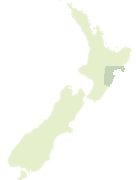

Scroll down to see a more detailed road map and below that a topographical map showing the location of Peninsula Stream. The road map has been supplied by openstreetmap and the topographical map of Peninsula Stream has been supplied by Land Information New Zealand (LINZ).

Yes you can use the top static map for you school/university project or personal website with a link back. Contact me for any commercial use.

Peninsula Stream Map New Zealand


New Zealand places in our database
[ A ] [ B ] [ C ] [ D ] [ E ] [ F ] [ G ] [ H ] [ I ] [ J ] [ K ] [ L ] [ M ] [ N ] [ O ] [ P ] [ Q ] [ R ] [ S ] [ T ] [ U ] [ V ] [ W ] [ X ] [ Y ] [ Z ]


Closest 20 Streams to Peninsula Stream

Tiokapu Stream ( 2.42km )   Deep Stream ( 2.85km )   Mangaone River ( 3.2km )   Parakohi Stream ( 3.73km )   Glenshee Stream ( 4.2km )   Mangak?pikopiko Stream ( 4.29km )   Mangakopikopiko Stream ( 4.29km )   Patoka Stream ( 4.79km )   Waikokomiko Stream ( 5.46km )   Mangahina Stream ( 5.73km )   Glenroy Stream ( 6.06km )   Otakowai Stream ( 6.51km )   Rautoiti Stream ( 6.6km )   Pokopoko Stream ( 6.78km )   Kaiwaka Stream ( 6.91km )   Mangarangiora Stream ( 7.13km )   Deep Stream ( 7.81km )   Munro Stream ( 8.19km )   Wakinakitangata Stream ( 8.3km )   Kings Stream ( 9.42km )   Waipuna Stream ( 9.57km )   Waiiti Stream ( 9.94km )   Pekapeka Stream ( 10.41km )   Waterfall Stream ( 10.55km )   Opau Stream ( 11.24km )   Ohurakura Stream ( 12.4km )   Okurakura Stream ( 12.4km )   Camp Stream ( 12.42km )   Tamingimingi Stream ( 12.95km )   Waihau Stream ( 13.1km )   Poningo Stream ( 13.2km )   Pakuratahi Stream ( 13.55km )   P?kuratahi Stream ( 13.55km )   Te Ngaru Stream ( 14.15km )   Te Ngarue Stream ( 14.15km )   Mangaone Stream ( 14.45km )   Inangatahi Stream ( 14.66km )   Tararere Stream ( 14.9km )   Rauwirikokomuka Stream ( 15.58km )   Kotomangengi Stream ( 16.43km )