Map showing location of Pakuka Stream


LINZ description: Stream located between the Waimata River in the south and the Wainui River in the north.
Latitude: -40.516419
Longitude: 176.510323
Northing: 5509000
Easting: 1897400
Land District: Hawke's Bay
Feat Type: Stream
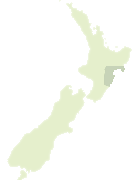

Scroll down to see a more detailed road map and below that a topographical map showing the location of Pakuka Stream. The road map has been supplied by openstreetmap and the topographical map of Pakuka Stream has been supplied by Land Information New Zealand (LINZ).

Yes you can use the top static map for you school/university project or personal website with a link back. Contact me for any commercial use.

Pakuka Stream Map New Zealand


New Zealand places in our database
[ A ] [ B ] [ C ] [ D ] [ E ] [ F ] [ G ] [ H ] [ I ] [ J ] [ K ] [ L ] [ M ] [ N ] [ O ] [ P ] [ Q ] [ R ] [ S ] [ T ] [ U ] [ V ] [ W ] [ X ] [ Y ] [ Z ]


Closest 20 Streams to Pakuka Stream

Waimata River ( 2.33km )   Mangaone Stream ( 4.04km )   Tapui Stream ( 8.29km )   Wainui River ( 8.33km )   Tautane Stream ( 8.59km )   Waikopiro Stream ( 8.73km )   Mangaohau Stream ( 8.79km )   Middle Creek ( 8.81km )   Wakawaihine Stream ( 9.4km )   Wimbledon Stream ( 10.48km )   Otuarehua Stream ( 10.99km )   Mangahewa Stream ( 11.11km )   Mangahuia Stream ( 14.42km )   Whangaehu River ( 14.97km )   Motuhinahina Stream ( 15.33km )   Tahuokaretu Stream ( 16.23km )   Waiotiaki Stream ( 16.34km )   Rakaupuhipuhi Stream ( 16.36km )   Iris Stream ( 16.38km )   Mangato Stream ( 16.58km )   Mangaone Stream ( 17.15km )   Mangamaire Stream ( 18.27km )   Waihoro Stream ( 18.7km )   Manawaangiangi Stream ( 18.88km )   Akitio River ( 18.95km )   Riddley Stream ( 20.34km )   Ossa Stream ( 20.4km )   Waihi Stream ( 21.23km )   Mangareia Stream ( 21.53km )   Birch Stream ( 21.6km )   Harolds Creek ( 21.64km )   Te Tohe Stream ( 21.72km )   Kahika Stream ( 22.03km )   Makukupara Stream ( 22.13km )   Mangaorapa Stream ( 22.62km )   Red River ( 22.7km )   Table Stream ( 23.09km )   Waitotara Stream ( 23.14km )   Aohanga River ( 23.25km )   Owahanga River ( 23.25km )