Map showing location of Nga-Hina a te Purewa Bay


LINZ description: Bay located on east side of Lake Waikaremoana.
Latitude: -38.769068
Longitude: 177.012062
Northing: 5701200
Easting: 1948600
Land District: Gisborne
Feat Type: Bay
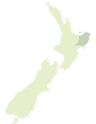

Scroll down to see a more detailed road map and below that a topographical map showing the location of Nga-Hina a te Purewa Bay. The road map has been supplied by openstreetmap and the topographical map of Nga-Hina a te Purewa Bay has been supplied by Land Information New Zealand (LINZ).

Yes you can use the top static map for you school/university project or personal website with a link back. Contact me for any commercial use.

Nga-Hina a te Purewa Bay Map New Zealand


New Zealand places in our database
[ A ] [ B ] [ C ] [ D ] [ E ] [ F ] [ G ] [ H ] [ I ] [ J ] [ K ] [ L ] [ M ] [ N ] [ O ] [ P ] [ Q ] [ R ] [ S ] [ T ] [ U ] [ V ] [ W ] [ X ] [ Y ] [ Z ]


Closest 20 Bays to Nga-Hina a te Purewa Bay

Te Kopua Bay ( 0.67km )   Te Rata Bay ( 0.84km )   Marauiti Bay ( 1.01km )   Wairaomoana (Wairau Arm) ( 1.13km )   Ohinekura Bay ( 1.3km )   Te Totara Bay ( 1.32km )   Korotipa Bay ( 1.57km )   Maraunui Bay ( 1.91km )   Ahimanu Bay ( 1.94km )   Whakawakawa Bay ( 1.98km )   Whakenepuru Bay ( 2.48km )   Pakiwaha Bay ( 2.72km )   Paraharaha Bay ( 2.95km )   Te Raoa Bay ( 3.03km )   Upokororo Bay ( 3.16km )   Wairoa Bay ( 3.44km )   Te Piripiri Bay ( 3.47km )   Te Korokoroowhaitiri Bay ( 3.67km )   Wekaku Bay ( 3.97km )   Paengarua Bay ( 4.21km )   Papaotehiwera Bay ( 4.46km )   Otekuri Bay ( 5.19km )   Waitio Bay ( 5.23km )   Hauotaruke Bay ( 5.28km )   Hoaitaruke Bay ( 5.28km )   Pakiaka Bay ( 5.31km )   Onewhero Bay ( 5.44km )   Tapuaenui Bay ( 5.44km )   Te Ihootoko Bay ( 5.58km )   Ohinetekawa Bay ( 6.13km )   Whanganui Inlet ( 6.17km )   Apiti Bay ( 6.41km )   Paraeroa Bay ( 6.58km )   Mokau Inlet ( 7.19km )   Rakaiaho Bay ( 8.1km )   Sandy Bay ( 9.56km )   Te Whero Bay ( 9.69km )   Onepoto Bay ( 9.82km )   Whatapo Bay ( 10.08km )   Rosie Bay ( 10.14km )