Map showing location of Clive


LINZ description: Feature shown on: NZMS260 V21 Edition 1 1981 Limited Revision 1996
Latitude: -39.586736
Longitude: 176.912747
Northing: 5610791.1
Easting: 1936045.2
Land District: Hawke's Bay
Feat Type: Town
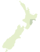

Scroll down to see a more detailed road map and below that a topographical map showing the location of Clive. The road map has been supplied by openstreetmap and the topographical map of Clive has been supplied by Land Information New Zealand (LINZ).

Yes you can use the top static map for you school/university project or personal website with a link back. Contact me for any commercial use.

Clive Map New Zealand


New Zealand places in our database
[ A ] [ B ] [ C ] [ D ] [ E ] [ F ] [ G ] [ H ] [ I ] [ J ] [ K ] [ L ] [ M ] [ N ] [ O ] [ P ] [ Q ] [ R ] [ S ] [ T ] [ U ] [ V ] [ W ] [ X ] [ Y ] [ Z ]


Closest 20 Towns to Clive

Haumoana ( 4.23km )   Hastings ( 8.12km )   Napier ( 9.52km )   Havelock North ( 9.7km )   Papapara Island ( 17.13km )   Pututaranui ( 21.89km )   Taupata ( 36.64km )   The Pigsty ( 37.87km )   Littles Clearing ( 53.32km )   Ngahere Experimental Basin ( 53.92km )   Waipukurau ( 54.9km )   The Wedge ( 55.71km )   Castle Camp ( 57.65km )   The Flounder ( 63.87km )   Buttercup Hollow ( 67.2km )   Unknown Campsite ( 68.94km )   Ngamahango ( 74.07km )   Tikitiki Woolwash ( 74.33km )   Wairoa ( 74.84km )   Ngatokaihoa ( 74.98km )   Makahakaha ( 75.43km )   East Patch ( 79.65km )   Ngawhakarara ( 90.06km )   Taihape ( 96.11km )   Upokoatihi Clearing ( 96.61km )   Hopuruahine Landing ( 97.74km )   Arataura ( 98.22km )   Hine Waho ( 98.3km )   Dannevirke ( 98.49km )   Puna Teao ( 98.64km )   Poroporo ( 98.74km )   Puna Hokoi ( 99.02km )   Imjin Camp ( 100.22km )   Whites Clearing ( 100.38km )   The Old Mans Hat ( 102.62km )   Six Cross ( 105.01km )   Minginui ( 106.1km )   Ohu Camp ( 107.04km )   HMNZS Irirangi ( 107.04km )   Helwan Camp ( 107.3km )