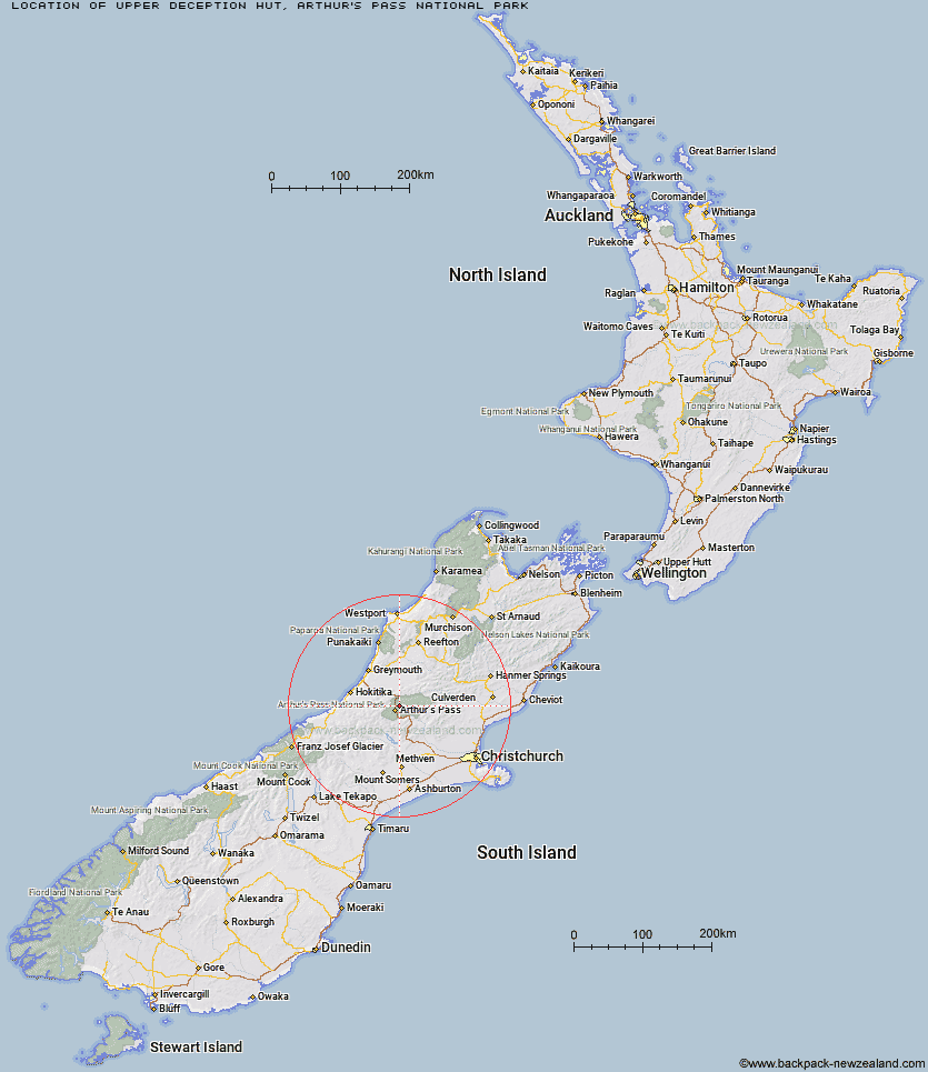
Topo Map showing location of Upper Deception Hut
This information is sourced from DoC, LINZ and Openstreetmap. Some of the hut photos are mine and the rest are from DoC. I will be adding an upload feature soon so people can photos of .Upper Deception Hut.
Basic info: basic six-bunk hut in the Hokitika area.
Latitude: -42.8841403355
Longitude: 171.617031807
Location: Arthur's Pass National Park
Area: Canterbury
Type of Hut: Basic/bivvies
Tracks: Mingha - Deception Route
Map: BV20 Topo Map | Road Map
Does this hut still exist? Have any more information? Contact
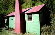
Image: DoC
Scroll down to see a topographical map and road map showing the location of Upper Deception Hut
[ A ] [ B ] [ C ] [ D ] [ E ] [ F ] [ G ] [ H ] [ I ] [ J ] [ K ] [ L ] [ M ] [ N ] [ O ] [ P ] [ Q ] [ R ] [ S ] [ T ] [ U ] [ V ] [ W ] [ Y ] [ Z ]
Closest 20 Huts to Upper Deception Hut
These are as the crow fliesGoat Pass Hut 2.04km Mingha Bivouac 4.42km Jacks Hut 6.16km Edwards Hut 6.89km Otehake Hut 8.18km Pfeifer Bivouac 9.82km Hawdon Hut 9.89km Sudden Valley Bivouac 10.2km Crow Hut 10.48km Hunts Creek Hut 10.57km Waimakariri Falls Hut 11.17km Greyneys Shelter 11.35km Carroll Hut 11.68km Koropuku Hut 12.5km East Hawdon Bivouac 13.08km Klondyke Shelter 13.33km Worsley Bivouac 14.01km Mid Taipo Hut 14.65km Poulter Bivouac 14.7km Dillon Hut 15.21km Anti Crow Hut 15.46km Dillons Homestead Hut 15.53km Hawdon Shelter 15.65km Old Julia Hut 15.69km Julia Hut 15.75km Carrington Hut 16.11km Poulter Hut 16.19km Dunns Creek Hut 16.32km Bealey Spur Hut 16.99km Bealey Hut 17.2km Kiwi Hut 17.5km Townsend Hut 17.9km Riversdale Hut 18.45km Minchin Bivouac 18.62km Trust/Poulter Hut 18.69km Scottys Bivouac 18.77km Andrews Shelter 18.83km Lagoon Saddle Hut 19.02km Lagoon Saddle A Frame Hut 19.05km Jacko Flat Hut 19.62km