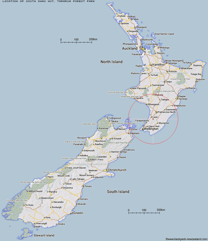
Topo Map showing location of South Ohau Hut
This information is sourced from DoC, LINZ and Openstreetmap. Some of the hut photos are mine and the rest are from DoC. I will be adding an upload feature soon so people can photos of .South Ohau Hut.
Basic info: standard 10-bunk hut in the Kapiti region.
Latitude: -40.7180074044
Longitude: 175.389868603
Location: Tararua Forest Park
Area: Wellington/Kapiti
Type of Hut: Standard
Map: BN33 Topo Map | Road Map
Does this hut still exist? Have any more information? Contact
Basic info: standard 10-bunk hut in the Kapiti region.
Latitude: -40.7180074044
Longitude: 175.389868603
Location: Tararua Forest Park
Area: Wellington/Kapiti
Type of Hut: Standard
Map: BN33 Topo Map | Road Map
Does this hut still exist? Have any more information? Contact
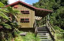
Image: DoC
Scroll down to see a topographical map and road map showing the location of South Ohau Hut
[ A ] [ B ] [ C ] [ D ] [ E ] [ F ] [ G ] [ H ] [ I ] [ J ] [ K ] [ L ] [ M ] [ N ] [ O ] [ P ] [ Q ] [ R ] [ S ] [ T ] [ U ] [ V ] [ W ] [ Y ] [ Z ]
Closest 20 Huts to South Ohau Hut
These are as the crow fliesTe Matawai Hut 2.29km North Ohau Hut 2.58km Waiopehu Hut 2.92km Mangahao Flats Hut 4.86km Arete Hut 5.23km Dracophyllum Hut 5.74km Dundas Hut 6.42km Arete Forks Hut 7.62km Carkeek Hut 8.05km Tarn Ridge Hut 8.97km Cattle Ridge Hut 9.66km Nichols Hut 10.32km Dorset Ridge Hut 10.33km Cow Creek Hut 10.74km Roaring Stag Hut 11.44km Herepai Hut 11.6km Waikawa Shelter 12.05km McGregor Bivouac 12.88km Mid King Bivouac 13.13km Blue Range Hut 13.71km Waitewaewae Hut 14.4km Anderson Memorial Hut 14.57km Mitre Flats Hut 14.58km Jumbo Hut 15.73km Burn Hut 15.96km Mid Waiohine Hut 17.36km Atiwhakatu Hut 17.55km Powell Hut 18.77km Aokaparangi Hut 19.49km Mountain House Shelter 19.95km Maungahuka Hut 22.11km Penn Creek Hut 22.19km Totara Flats Hut 23.9km Field Hut 23.92km Neill Forks Hut 24.05km Sayer Hut 25.41km North Mangahao Bivouac 26.79km Kime Hut 26.9km Kapakapanui Hut 29.64km Waiotauru Hut 30.01km