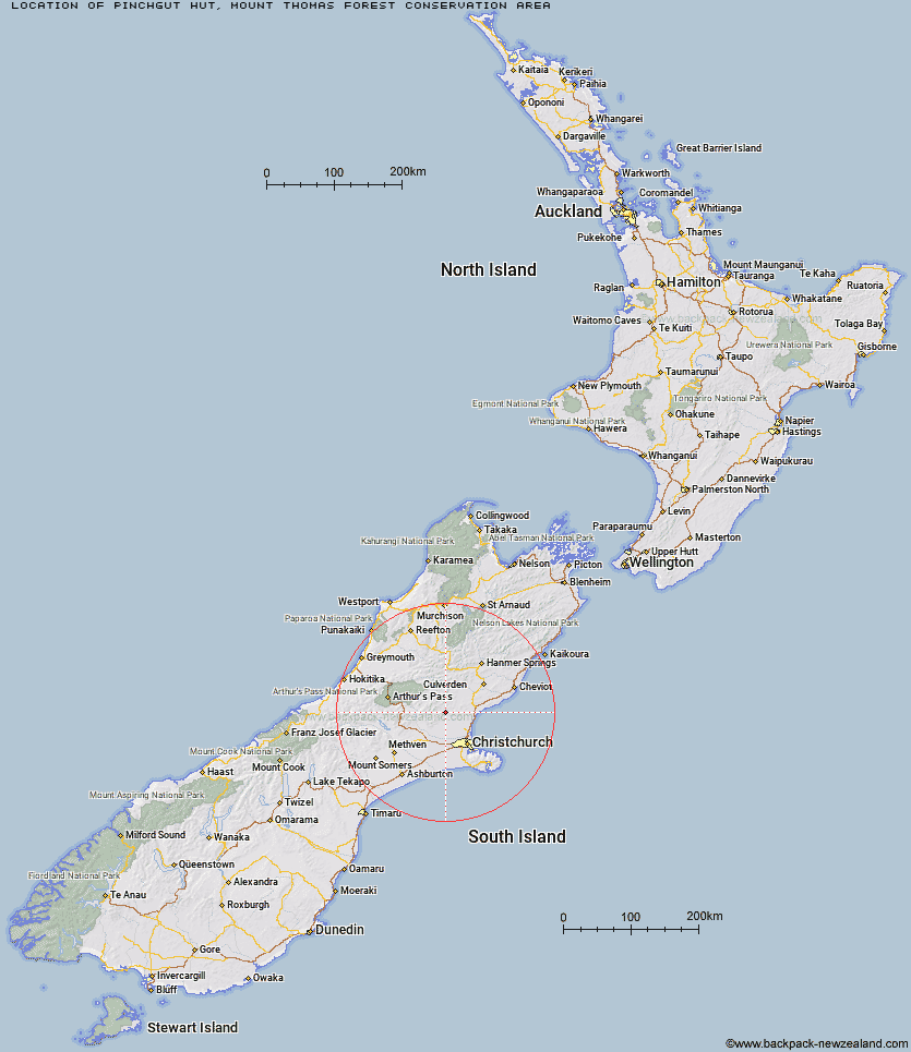
Topo Map showing location of Pinchgut Hut
This information is sourced from DoC, LINZ and Openstreetmap. Some of the hut photos are mine and the rest are from DoC. I will be adding an upload feature soon so people can photos of .Pinchgut Hut.
Basic info: standard nine-bunk hut in the North Canterbury and Arthur's Pass area.
Latitude: -43.1294275276
Longitude: 172.337447458
Location: Mount Thomas Forest Conservation Area
Area: Canterbury
Type of Hut: Standard
Tracks: Pinchgut Track
Map: BW23 Topo Map | Road Map
Does this hut still exist? Have any more information? Contact
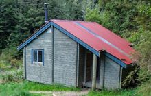
Image: DoC
Scroll down to see a topographical map and road map showing the location of Pinchgut Hut
[ A ] [ B ] [ C ] [ D ] [ E ] [ F ] [ G ] [ H ] [ I ] [ J ] [ K ] [ L ] [ M ] [ N ] [ O ] [ P ] [ Q ] [ R ] [ S ] [ T ] [ U ] [ V ] [ W ] [ Y ] [ Z ]
Closest 20 Huts to Pinchgut Hut
These are as the crow fliesBob's Camp Bivouac 3.99km Lilburne Hut 16.67km Youngman Stream Hut 17.07km Tarn Hut 18.3km Tommys Cabin 22.5km Adams Hut 23.06km Cattle Creek Hut 23.84km Seldom Inn Hut 24.88km Wharfedale Hut 25.26km Black Hill Hut 27.44km Esk Bivouac 27.65km Anna Hut 28.46km Lower Salmon Creek Bivouac 29.18km Anderson's Hut 29.3km Puketeraki Bivouac 29.62km Hamilton Hut 30.12km Walker Hut 32.11km Kinnebrooks Hut 32.74km Ant Stream Hut 32.81km Lochinvar Hut 34.5km Ant Stream Bivouac 35.13km Deep Creek Hut 35.33km Petticoat Junction Hut 35.39km Rosa Hut 35.75km Bush Camp Hut 38.49km Turnbull Bivouac 39.83km Bull Creek Hut 39.89km Broken River Hut 41.21km Glenrae Hut 41.33km Candlesticks Bivouac 42.04km North Esk Hut 42.58km Cold Stream Hut 43.02km Stony Stream Hut 45.32km Jollie Brook Hut 45.53km Gabriel Hut 45.55km Lake Mason Hut 45.62km Andrews Shelter 46.73km Ranger Bivouac 47.05km South Branch Research Hut 47.54km Riversdale Hut 47.58km