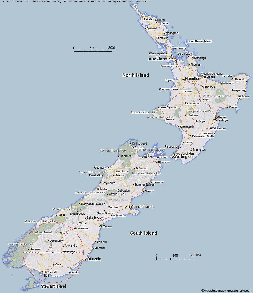
Topo Map showing location of Junction Hut
This information is sourced from DoC, LINZ and Openstreetmap. Some of the hut photos are mine and the rest are from DoC. I will be adding an upload feature soon so people can photos of .Junction Hut.
Basic info: standard six-bunk hut in the Central Otago area.
Latitude: -45.5599092321
Longitude: 168.897115022
Location: Old Woman and Old Man/Kopuwai Ranges
Area: Otago
Type of Hut: Standard
Map: CD12 Topo Map | Road Map
Does this hut still exist? Have any more information? Contact
Basic info: standard six-bunk hut in the Central Otago area.
Latitude: -45.5599092321
Longitude: 168.897115022
Location: Old Woman and Old Man/Kopuwai Ranges
Area: Otago
Type of Hut: Standard
Map: CD12 Topo Map | Road Map
Does this hut still exist? Have any more information? Contact
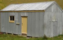
Image: DoC
Scroll down to see a topographical map and road map showing the location of Junction Hut
[ A ] [ B ] [ C ] [ D ] [ E ] [ F ] [ G ] [ H ] [ I ] [ J ] [ K ] [ L ] [ M ] [ N ] [ O ] [ P ] [ Q ] [ R ] [ S ] [ T ] [ U ] [ V ] [ W ] [ Y ] [ Z ]
Closest 20 Huts to Junction Hut
These are as the crow fliesFlaxy Hut 1.35km Titan Huts 6.19km Dome Hut 7.65km Blue Lake Huts 9.48km Hyde Home Hut 10.1km Jim Baird Hut 11.53km Black Hut 11.66km Sullivan Hut 12.35km Stronach Hut 13.77km Bush Huts 14.6km Mud Hut 14.93km Slate Hut 15.15km Garston Ski Hut 16.54km Christies Hut 17.43km Junction Hut 23.01km McCrimmons Hut 23.57km Andrew Rees Hut 24.05km Potters Huts 24.29km Leithen Hut 25.3km Diggers Hut 25.72km Baileys Hut 28.47km Beaumont Hut 29.47km Boundary Hut 32.07km Nicholsons Hut 32.22km Mitchells Hut 34.07km Mansion Hut 37.44km Whites Hut 37.74km Ross Hut 37.77km Cowshed Hut 39.22km Shepherd Creek Hut 40.18km Mt Bee Bunkrooms 41.04km Siberia Hut 41.27km Old Woman Hut 41.39km Cromel Base Hut 42.36km Irthing Hut 42.79km Cromel Branch Hut 42.94km Two Mile Hut 43.48km Dog Box Bivouac 44.44km Billy Hut 45.09km Upper Cromel Hut 46.18km